How to build a sustainable cruise port
THE IMPACT OF CRUISING ON THE CARIBBEAN
Growth in cruise traffic is usually perceived as positive. Growth in ship size and passenger volumes increases business. More Caribbean communities today make a living by providing services to cruise ships and the passengers. However, as the cruise business grows, the negative impact is revealed in the form of deteriorating beaches, reefs and nature sites, traffic jams and increasing levels of crime. How do we deal with this and how far can we go? What are the limits of acceptability and how do we ensure that these limits are not exceeded? Ports have a responsibility to ensure the limits are not exceeded.
It makes perfect business sense to plan sustainability when developing cruise ports and destinations. Sustainable means that tourists can continue to enjoy nature’s beauty while nationals can continue to make a decent living from the opportunities that tourism offers, while at the same time enjoying the land they call home. With community-based cooperation and development programmes this is achievable, provided all stakeholders agree on the level and type of tourism that is acceptable for their particular destination.
MONITORING AND PROTECTING THE MARINE ENVIRONMENT
The cruise industry is still growing. And nations in the Caribbean have come to regard access to the cruise industry as economically favourable. Nothing comes without a cost. And, seen from an environmental point of view, the impact of the cruise industry is often forgotten when all the positive benefits are put in the headlines.
It is possible to develop ports and harbours in ways, which can significantly reduce the negative impacts of cruise shipping on the environment, many of which are often associated with their construction. To do this, background information about the environment is very important. For most port authorities, the wider environment and its condition is not a part of the work and so responsibility is normally shunted to the environmental authorities.
Initiating very close cooperation with relevant authorities, so as to establish common understanding of the need for protecting the environment is to be recommended.
Protecting the marine environment calls for a monitoring programme. This will establish knowledge about the seabed conditions at and around the harbours. It is important to realise that such investigations should be based on the fact that various impacts from port and construction activities travel far. In addition marine investigations should be based on continuity and should be repeated with regular intervals, depending on the types of seabed habitats found because nature is dynamic! Such investigations lead to the creation of a baseline, which describes the environmental conditions at the present level of human pressure (port operations, sewage discharge, fisheries, recreational water sports etc).
SO HOW DO YOU START?
The optimal way to begin is to create various impact maps. These maps document where present types of impacts occur, according to time, scale and space. This can be done with sophisticated GIS systems but could also be initiated with a much simpler approach. We suggest you start simple and get the information needed for entering into more advanced stages of monitoring, if conditions allow.
Take a look at the sea chart from your port and adjacent areas? Here you will see what the old seafarers observed when seeking port: information about reefs, sand bottom, gravel etc. Their main objective was to avoid having the ship wrecked and so they were always looking for good places to anchor. Interestingly, many of the old observations are still there. Now you already have a good basis from which to start. The next step should be to search for observations made by fishermen, divers and others who may have valuable information. Now add knowledge about coastal currents and you will then be able to assess spreading of fine-grained material, for example, if dredging is a part of either maintenance or construction activities. For all observations one should include seasonal differences which could alter the assessments. Be sure to include aerial photos, which may enable you to see many new structures and their extent on the seabed. You can also take advantage of using various types of satellite images, where analyses can add valuable information about the seabed composition.
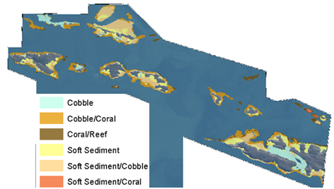
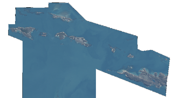
In the example below, the left shows the original image and the right shows the same image after interpretation. Most marine habitats do not change much over the year, except those, which are the result of sand transportation. Seagrass beds and coral reefs are examples of habitats established where changes to the seabed are infrequent.
Despite efforts to protect important marine habitats, port and coastal development may eventually cause problems. It is therefore the duty of the port and the authorities to ensure minimum damage to the environment. The most fragile habitats are seagrass beds, coral reefs and other hard bottom habitats like rocks. Certain types of sandy habitats may be very important feeding grounds for fish. Good baseline maps of the areas in and around the harbour will help planners understand which impacts to minimise before, during and after the construction.
MARINE ENVIRONMENTAL PROTECTION REGULATION
The Caribbean was declared a ‘Special Protected Area’ by the International Maritime Organisation (IMO) and the maritime community wants to implement MARPOL regulations to better protect the marine environment. Of particular importance are the so-called ‘MARPOL annexes’. They provide guidelines to minimise various forms of ship pollution, including oil, sound and atmospheric pollution; toxic ballast water pollution, introduction of invasive marine species, as well as direct wild life damage due to collisions.
Under the so-called ‘Cartagena Convention’, the Caribbean states work together to maximize the implementation of the relevant IMO instruments. Under the UNEP banner, IMO is financing regional programmes to assist Caribbean governments to successfully implement these instruments. National legislation is important, particularly in case of deliberate or accidental violations, when corrective action is required. Hence, when implementing legislation, the cost of supervision and policing should be budgeted. Regional institutions like the Rac/Rempeitc in Curaçao can assist with this.
LAND-BASED IMPACT
Thousands of passengers coming ashore day after day will have a severe impact on the cruise destination. An entire service economy has developed around visits. Passengers and crew have needs and the destinations cater to them by offering a wide range of tourism and transportation services. The high volumes and concentrated time span of most cruise visits are a major challenge for the destination. Just to manage the crowds and vehicular traffic on narrow streets in a manner that ensures that a visitor’s stay is enjoyable is no small effort and requires sacrifice and patience on all sides. Yes, most Caribbean people do welcome the tourists but they also want to be able to get to work and take their children to school on time. If the roads and intersections are frequently congested as tour buses and taxis take ownership, local support for cruise tourism may quickly decline. And we haven’t even mentioned impacts from increased car exhaust, CO2, etc!
LOCAL CAPACITY RESEARCH AND YOUR GROWTH STRATEGY
Cruise tourists pay in US dollars. This reality tends to attract not only local nationals but also people from other parts of the country or even from abroad. This can change the social structure of the smallest Caribbean communities. Social control mechanisms deteriorate and youth are not well prepared to deal with the dollar-based lifestyle that invades their country, fuelling crime, drug abuse, prostitution and other deviant behaviour. Health care, education and youth social programmes are collectively the best way to deal with these issues.
Like the effects on the marine and land environments, the socio-economic effects must also be studied in advance. This also requires a “baseline” capacity study in which infrastructure and transportation capacity and crime, immigration and population statistics are analysed and applied to the over-all cruise growth strategy. This study should pinpoint the obstacles for growth and set limits to the amount of passengers that the destination can handle on any particular day.
As with the marine environment, nature and historic sites must also be monitored and protected by legislation from misuse, over use and deterioration. All this requires the involvement of various government ministries and departments, as well as environmental and other community groups. Collectively they can assist in supplying both the data and the volunteers for monitoring and assisting.
INVOLVE LOCAL STAKEHOLDERS IN PLANNING AND DESIGN
It is clear that building a sustainable cruise port and destination is much more than doing technical surveys and designs and then ‘dredge and build’. The level of cruise tourism and the small size of most Caribbean destinations require a long-term, multi-disciplinary approach that involves many government agencies and community groups. The described capacity study can set the framework and limits for growth. They can be a cornerstone for building a successful strategy for port development, one which protects the investment. Non-traditional local partners can contribute, for free, local data, which is priceless for determining how, how fast and how far your cruise port should grow. We suggest that you start smart, by making use of local knowledge and by harnessing the goodwill and dedication, not only by listening to the people but by actually involving them in your destination planning and port design.
by JAN SIERHUIS* and JESPER GOODLEY DANNISØE**


